|
Alpine Meadows trail map is available as part of our USA/Canada Ski App. It is supported on iPhone / iPad, Android, Windows 8 Phone and Blackberry.
Alpine Meadows is a ski resort located in Alpine Meadows, California of North Lake Tahoe. Alpine Meadows offers 2,400 acres of skiable terrain, 13 different lifts and a vertical drop of 1,800 ft.[1][2...(From Wikipedia page of Alpine Meadows Ski Resort).
Want to know what others are saying about our app? Go here to see our reviews and coverage. This app is available as part of USA/Canada Ski App package to suit your skiing needs. Have more questions about the Ski App? Ask us.
|
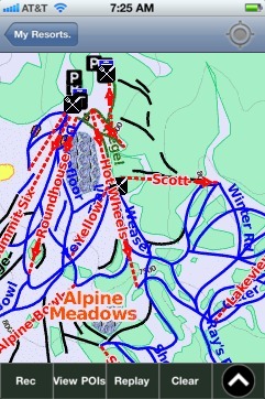 Alpine Meadows: Gps Ski Maps - iPhone Ski App |
||||||||||||||||||||||||||