|
Arapahoe Basin trail map is available as part of our USA/Canada Ski App. It is supported on iPhone / iPad, Android, Windows 8 Phone and Blackberry.
Arapahoe Basin is an alpine ski area in the Rocky Mountains of the United States, in the White River National Forest of Colorado. A-Basin (or simply, "the Basin") is known for its extended season—of...(From Wikipedia page of Arapahoe Basin Ski Resort).
Want to know what others are saying about our app? Go here to see our reviews and coverage. This app is available as part of USA/Canada Ski App package to suit your skiing needs. Have more questions about the Ski App? Ask us.
|
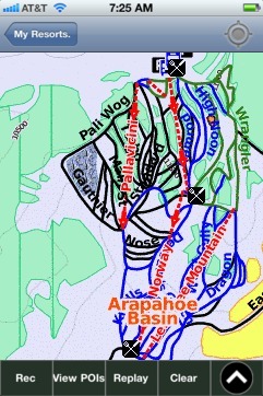 Arapahoe Basin: Gps Ski Maps - iPhone Ski App |
||||||||||||||||||||||||||||||||
Arapahoe Basin users
| Ski Resort | Type | Info | Date |
|---|---|---|---|
| Arapahoe Basin | Track | 1 runs, max 4.3807306 m/s, avg 2.57 m/s, 1 blue, Tracked on App | Friday, March 13th, 2015 |
| Arapahoe Basin | Track | 1 runs, max 1.4222517 m/s, avg 0.75 m/s, Tracked on App | Friday, March 13th, 2015 |
| Arapahoe Basin | Track | 1 runs, max 14.5837345 m/s, avg 4.47 m/s, 2 green, 6 blue, Tracked on App | Friday, March 13th, 2015 |