Bear Valley Ski App


Bear Valley trail map is available as part of our USA/Canada Ski App. It is supported on iPhone / iPad, Android, Windows 8 Phone and Blackberry.  

Bear Valley is a ski area located on highway 4 between Lake Tahoe and Yosemite—about three hours southeast of Sacramento, California. It is about one hour from Angels Camp, California. The alpine sk...(From Wikipedia page of Bear Valley Ski Resort).
 When you purchase our Ski App,  you get all the great ski app features, along with Bear Valley gps ski map.


Want to know what others are saying about our app? Go here to see our reviews and coverage.

This app is available as part of  USA/Canada Ski App package to suit your skiing needs.

Have more questions about the Ski App? Ask us.


Bear Valley Ski Stats
LocationAlpine County, California
Nearest cityAngels Camp, California
Coordinates38°29′32″N 120°00′24″W / 38.49222°N 120.00667°W / 38.49222; -120.00667Coordinates: 38°29′32″N 120°00′24″W / 38.49222°N 120.00667°W / 38.49222; -120.00667
Vertical1,900 ft (600 m)
Top elevation8,500 ft (2,600 m)
Base elevation6,600 ft (2,000 m)
Skiable area1,280 acres (520 ha)
Runs67 total 25% beginner 40% intermediate 35% advanced
Lift system10 (1 high-speed quad, 2 triples, 5 doubles, 1 carpet lift)
Lift capacityskiers/hr
Snowfall359 inches
Snowmaking100 acres (40 ha)
Web sitewww.bearvalley.com


Bear Valley ski map - iPhone Ski App
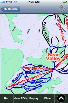
Bear Valley: Gps Ski Maps - iPhone Ski App