Blue Mountain(Ontario) Ski App


Blue Mountain(Ontario) trail map is available as part of our USA/Canada Ski App. It is supported on iPhone / iPad, Android, Windows 8 Phone and Blackberry.  

Blue Mountain is an alpine ski resort in Ontario, Canada, just northwest of Collingwood. It is situated on a section of the Niagara Escarpment about 1 km (0.6 mi.) from Nottawasaga Bay, and is a maj...(From Wikipedia page of Blue Mountain(Ontario) Ski Resort).
 When you purchase our Ski App,  you get all the great ski app features, along with Blue Mountain(Ontario) gps ski map.


Want to know what others are saying about our app? Go here to see our reviews and coverage.

This app is available as part of  USA/Canada Ski App package to suit your skiing needs.

Have more questions about the Ski App? Ask us.


Blue Mountain(Ontario) Ski Stats
LocationThe Blue Mountains, Ontario, Canada
Nearest cityCollingwood, Ontario
Coordinates44°30′00″N 80°19′00″W / 44.50000°N 80.31667°W / 44.50000; -80.31667 (Blue Mountain)
Vertical219 m - (720 ft)
Top elevation452 m - (1483 ft)
Base elevation226 m - (741 ft)
Skiable area102 ha - (250 acres)
Runs42 11 – Easiest 16 – More Difficult 8 – Most Difficult 7 – Expert
Longest run1.2 km - (0.75 mi.)
Lift system16 (5 high speed six person chairlifts, 5 Fixed grip chairlifts, 5 Magic Carpets, 1 Rope Tow)
Lift capacity21,690 per hour
Terrain parks3
Snowfall279 cm/year - (110 in.)
Snowmaking94%
Night skiingYes
Web siteBlueMountain.ca


Blue Mountain(Ontario) ski map - iPhone Ski App
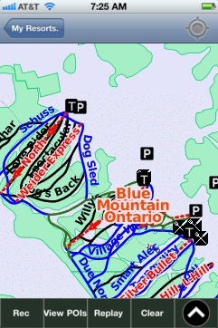
Blue Mountain(Ontario): Gps Ski Maps - iPhone Ski App