Bridger Bowl, MT Ski App


Bridger Bowl, MT trail map is available as part of our USA/Canada Ski App. It is supported on iPhone / iPad, Android, Windows 8 Phone and Blackberry.  

Bridger Bowl is a ski area near Bozeman, Montana, serving locals and students of Montana State University.(From Wikipedia page of Bridger Bowl, MT Ski Resort).
 When you purchase our Ski App,  you get all the great ski app features, along with Bridger Bowl, MT gps ski map.


Want to know what others are saying about our app? Go here to see our reviews and coverage.

This app is available as part of  USA/Canada Ski App package to suit your skiing needs.

Have more questions about the Ski App? Ask us.


Bridger Bowl, MT Ski Stats
LocationGallatin National ForestGallatin County, Montana United States
Nearest cityBozeman
Coordinates45°49′02″N 110°53′48″W / 45.81722°N 110.89667°W / 45.81722; -110.89667 (Bridger Bowl Ski Area)Coordinates: 45°49′02″N 110°53′48″W / 45.81722°N 110.89667°W / 45.81722; -110.89667 (Bridger Bowl Ski Area)
Vertical2600 ft - (790 m)
Top elevation8700 ft - (2650 m)
Base elevation6100 ft - (1860 m)
Skiable area2,000 acres (8.1 km2)
Runs71
Longest run3 miles - (5 km)
Lift system8 chairlifts 1 Quad 2 Triples 5 Doubles
Snowfall350" - (890 cm)
Snowmakingnone
Web siteBridger Bowl.com


Bridger Bowl, MT ski map - iPhone Ski App
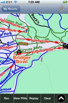
Bridger Bowl, MT: Gps Ski Maps - iPhone Ski App