Buttermilk Ski App


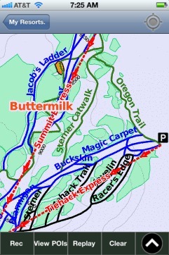
Buttermilk trail map is available as part of our USA/Canada Ski App. It is supported on iPhone / iPad, Android, Windows 8 Phone and Blackberry.  

Buttermilk Ski Area is frequently considered the easiest skiing mountain in Aspen, Colorado. Buttermilk has also been the host to the ESPN Winter X-games multiple times. It contains three ski areas: T...(From Wikipedia page of Buttermilk Ski Resort).
 When you purchase our Ski App,  you get all the great ski app features, along with Buttermilk gps ski map.


Want to know what others are saying about our app? Go here to see our reviews and coverage.

This app is available as part of  USA/Canada Ski App package to suit your skiing needs.

Have more questions about the Ski App? Ask us.


Buttermilk Ski Stats
LocationPitkin County, Colorado, USA
Nearest cityAspen, Colorado
Coordinates39°12′18″N 106°51′38″W / 39.20500°N 106.86056°W / 39.20500; -106.86056 (Buttermilk Mountain)
Top elevation9,900 feet (3,000 m)
Base elevation7,870 feet (2,400 m)
Skiable area435 acres (1.76 km2)
Runs44 total 35% beginner 39% intermediate 26% advanced 0% expert
Longest run3 miles (4.8 km)
Lift system8 total (3 high-speed quad chairs, 1 double chairs, 4 surface/ski school)
Terrain parks2, 1 superpipe
Snowfall200 in/year (5.08 m/year)
Web sitehttp://www.aspensnowmass.com


Buttermilk ski map - iPhone Ski App
Buttermilk: Gps Ski Maps - iPhone Ski App