|
Mount Baker-Snoqualmie National Forest(From Wikipedia page of Crystal Mountain Ski Resort).
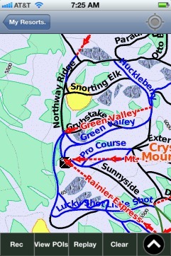
When you purchase our Ski App, you get all the great ski app features, along with Crystal Mountain gps ski map.
Want to know what others are saying about our app? Go here to see our reviews and coverage.
This app is available as part of USA/Canada Ski App package to suit your skiing needs.
Have more questions about the Ski App? Ask us.
| Crystal Mountain Ski Stats | | Location | Mount Baker-Snoqualmie National ForestPierce County,Washington, U.S. | | Nearest city | Enumclaw 40 mi. (65 km) north | | Coordinates | 46°55′40″N 121°28′56″W / 46.92778°N 121.48222°W / 46.92778; -121.48222 (Crystal Mountain) | | Vertical | 3,100 ft (945 m) 2,602 ft (793 m) - lifts | | Top elevation | 7,012 ft (2,137 m) 7,002 ft (2,134 m) - lifts | | Base elevation | 3,912 ft (1,192 m) 4,400 ft (1,341 m) - lifts | | Skiable area | 2,600 acres (10.5 km2) lift serviced: 2,300 acres (9.3 km2) inbounds backcountry 300 acres (1.2 km2) | | Runs | 57 - 11% easiest - 54% more difficult - 35% most difficult | | Longest run | 2.5 mi (4 km)"Northway" | | Lift system | 1 Gondola 10 chairs 1 magic carpet | | Lift capacity | 20,760 / hr | | Terrain parks | 1 | | Snowfall | 350 in (890 cm) | | Snowmaking | none | | Night skiing | none | | Web site | crystalmountainresort.com |
|
Crystal Mountain: Gps Ski Maps - iPhone Ski App |