Deer Valley Ski App


Deer Valley trail map is available as part of our USA/Canada Ski App. It is supported on iPhone / iPad, Android, Windows 8 Phone and Blackberry.  

Deer Valley is an alpine ski resort in the Wasatch Range, located 36 miles (58 km) east of Salt Lake City, in Park City, Utah, United States. The resort, known for its upscale amenities, is consisten...(From Wikipedia page of Deer Valley Ski Resort).
 When you purchase our Ski App,  you get all the great ski app features, along with Deer Valley gps ski map.


Want to know what others are saying about our app? Go here to see our reviews and coverage.

This app is available as part of  USA/Canada Ski App package to suit your skiing needs.

Have more questions about the Ski App? Ask us.


Deer Valley Ski Stats
LocationWasatch RangeSummit County, Utah United States
Nearest cityPark City, Utah
Coordinates40°37′22″N 111°29′22″W / 40.62278°N 111.48944°W / 40.62278; -111.48944Coordinates: 40°37′22″N 111°29′22″W / 40.62278°N 111.48944°W / 40.62278; -111.48944
Vertical3,000 ft (910 m)
Top elevation9,570 ft (2,920 m)
Base elevation6,570 ft (2,000 m)
Skiable area2,026 acres (820 ha)
Runs100 27% easiest 41% more difficult 32% most difficult
Longest run2.8 mi (4.5 km)
Lift system24 - 1 Gondola - 12 High-speed quad chairlifts - 1 Fixed-grip quad chairlift - 5 Triple chairlifts - 2 Double chairlifts - 4 Magic carpets
Lift capacity50,470 skiers/hr
Terrain parksNo
Snowfall300 inches (760 cm)
Snowmakingover 660 acres (270 ha)
Night skiingNo
Web siteDeer Valley


Deer Valley ski map - iPhone Ski App
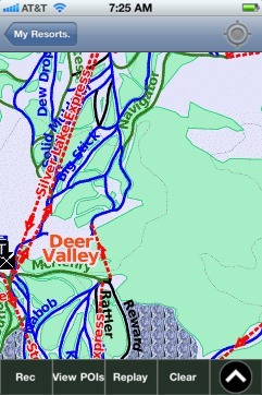
Deer Valley: Gps Ski Maps - iPhone Ski App