Dodge Ridge Ski App


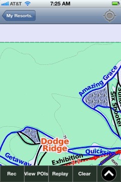
Dodge Ridge trail map is available as part of our USA/Canada Ski App. It is supported on iPhone / iPad, Android, Windows 8 Phone and Blackberry.  

Dodge Ridge Wintersports Area is a ski area near Pinecrest, California in Tuolumne County, off of Highway 108, 30 mi (48 km) east of Sonora. The resort in located in the Stanislaus National Forest a...(From Wikipedia page of Dodge Ridge Ski Resort).
 When you purchase our Ski App,  you get all the great ski app features, along with Dodge Ridge gps ski map.


Want to know what others are saying about our app? Go here to see our reviews and coverage.

This app is available as part of  USA/Canada Ski App package to suit your skiing needs.

Have more questions about the Ski App? Ask us.


Dodge Ridge Ski Stats
LocationDodge Ridge
Nearest cityPinecrest, California
Coordinates38°11′23″N 119°57′23″W / 38.1896°N 119.9564°W / 38.1896; -119.9564Coordinates: 38°11′23″N 119°57′23″W / 38.1896°N 119.9564°W / 38.1896; -119.9564
Vertical1,600 ft (490 m)
Top elevation8,200 ft (2,500 m)
Base elevation6,600 ft (2,000 m)
Skiable area832 acres (337 ha)
Runs62 total 20% beginner 40% intermediate 40% advanced
Longest run2 mi (3.2 km) (Stagecoach)
Lift system12 lifts: 1 quad, 3 triples, 5 doubles, 4 surface
Terrain parksProgression Stagecoach Rocky's Road
Snowfall300 to 500 in (760 to 1,300 cm)
Night skiingNone
Web sitewww.dodgeridge.com


Dodge Ridge ski map - iPhone Ski App
Dodge Ridge: Gps Ski Maps - iPhone Ski App