|
Aineck-Katschberg trail map is available as part of our Europe Ski App. It is supported on iPhone / iPad, Android, Windows 8 Phone and Blackberry.
Katschberg Pass (el. 1,641 m (5,384 ft)) is a high mountain pass in the Central Eastern Alps in Austria between Rennweg am Katschberg in the state of Carinthia and Sankt Michael im Lungau in Salzbur...(From Wikipedia page of Aineck-Katschberg Ski Resort).
Want to know what others are saying about our app? Go here to see our reviews and coverage. This app is available as part of Europe Ski App package to suit your skiing needs. Have more questions about the Ski App? Ask us.
Other related Ski Resorts
|
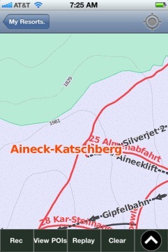 Aineck-Katschberg: Gps Ski Maps - iPhone Ski App
|
|||||||||||||||||