|
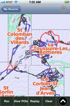
Les Sybelles trail map is available as part of our Europe Ski App. It is supported on iPhone / iPad, Android, Windows 8 Phone and Blackberry. Les Sybelles resort complex contains the following ski resorts: St Sorlin d'Arves, St Colomban des Villards, La Toussuire-Les Bottieres, Le Corbier-St Jean d'Arves.
Les Sybelles is a French linked ski area, located in the Savoie department in the Alps. It is one of the largest skiable domains in France. The resort was the home base of Jean-Pierre Vidal, winner of...(From Wikipedia page of Les Sybelles Ski Resort).
Want to know what others are saying about our app? Go here to see our reviews and coverage. This app is available as part of Europe Ski App package to suit your skiing needs. Have more questions about the Ski App? Ask us.
Other related Ski Resorts
|
 Les Sybelles: Gps Ski Maps - iPhone Ski App
|
|||||||||||||||||||||