Grouse Mountain, BC Ski App


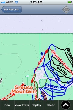
Grouse Mountain, BC trail map is available as part of our USA/Canada Ski App. It is supported on iPhone / iPad, Android, Windows 8 Phone and Blackberry.  

Grouse Mountain is one of the North Shore Mountains of the Pacific Ranges in North Vancouver, British Columbia, Canada. Exceeding 1,200 m (4,000 feet) in altitude at its peak, is the site of an alpine...(From Wikipedia page of Grouse Mountain, BC Ski Resort).
 When you purchase our Ski App,  you get all the great ski app features, along with Grouse Mountain, BC gps ski map.


Want to know what others are saying about our app? Go here to see our reviews and coverage.

This app is available as part of  USA/Canada Ski App package to suit your skiing needs.

Have more questions about the Ski App? Ask us.


Grouse Mountain, BC Ski Stats
LocationBritish Columbia Canada
Nearest cityNorth Vancouver
Coordinates49°22′46.40″N 123°04′54.49″W / 49.3795556°N 123.0818028°W / 49.3795556; -123.0818028 (Grouse Mountain)
Vertical365 m (1,198 ft)
Top elevation1,231 m (4,039 ft)
Base elevation274 m (899 ft)
Skiable area212 acres
Runs26 (14 night skiing) 17% beginner 54% intermediate 21% advanced 8% expert
Lift system4 chairlifts 1 magic carpet
Web siteGrouseMountain.com
Elevation1,231 m (4,039 ft)
Prominence86 m (282 ft)
LocationBritish Columbia, Canada
RangeHowe Sound Group
Coordinates49°23′10″N 123°04′35″W / 49.38611°N 123.07639°W / 49.38611; -123.07639
Topo mapNTS 92G/06


Grouse Mountain, BC ski map - iPhone Ski App
Grouse Mountain, BC: Gps Ski Maps - iPhone Ski App