|
Homewood trail map is available as part of our USA/Canada Ski App. It is supported on iPhone / iPad, Android, Windows 8 Phone and Blackberry.
Homewood Mountain Resort is a ski area located on the west shore of Lake Tahoe in the state of California, a few miles south of Tahoe City in the town of Homewood. It has 1,260 acres (510 ha) of skia...(From Wikipedia page of Homewood Ski Resort).
Want to know what others are saying about our app? Go here to see our reviews and coverage. This app is available as part of USA/Canada Ski App package to suit your skiing needs. Have more questions about the Ski App? Ask us.
|
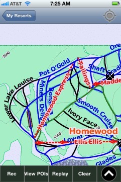 Homewood: Gps Ski Maps - iPhone Ski App |
||||||||||||||||||||||||||