|
Jay Peak trail map is available as part of our USA/Canada Ski App. It is supported on iPhone / iPad, Android, Windows 8 Phone and Blackberry.
Jay Peak Resort is an American ski resort located on Jay Peak in the Green Mountains, between the Village of Jay and Montgomery Center, Vermont. Its vertical drop of 2,153 feet (656 m) is the eighth ...(From Wikipedia page of Jay Peak Ski Resort).
Want to know what others are saying about our app? Go here to see our reviews and coverage. This app is available as part of USA/Canada Ski App package to suit your skiing needs. Have more questions about the Ski App? Ask us.
|
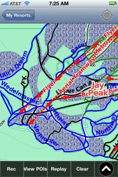 Jay Peak: Gps Ski Maps - iPhone Ski App |
||||||||||||||||||||||||||