Keystone Ski App


Keystone trail map is available as part of our USA/Canada Ski App. It is supported on iPhone / iPad, Android, Windows 8 Phone and Blackberry.  

Keystone Resort is the largest ski resort in Summit County located in Keystone, Colorado, United States. It was founded on November 21, 1970 by Max Dercum. The resort is owned and operated by Vail Res...(From Wikipedia page of Keystone Ski Resort).
 When you purchase our Ski App,  you get all the great ski app features, along with Keystone gps ski map.


Want to know what others are saying about our app? Go here to see our reviews and coverage.

This app is available as part of  USA/Canada Ski App package to suit your skiing needs.

Have more questions about the Ski App? Ask us.


Keystone Ski Stats
LocationWhite River National ForestSummit County, Colorado, USA
Nearest cityKeystone, Colorado
Coordinates39°36′18″N 105°57′15″W / 39.60500°N 105.95417°W / 39.60500; -105.95417 (Keystone Resort)
Top elevation12,408 feet (3,782 m)
Base elevation9,280 feet (2,830 m)
Skiable area3148 acres (12.7km²)
Runs135 total (19% beginner 32% intermediate 49% advanced/expert)
Longest runSchoolmarm - 3.5 miles (5.6 km)
Lift system19 total (2 gondolas, 12 chair lifts (one high speed six pack, five high speed quads, one fixed grip quad, one triple chairlift, three double chairlifts), 5 surface lifts)
Snowfall330 in/year (8.4 m/year)
Snowmaking662+ acres
Night skiing15 trails
Web sitehttp://www.keystoneresort.com/


Keystone ski map - iPhone Ski App
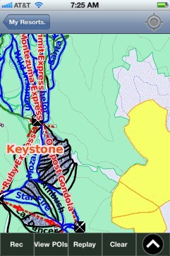
Keystone: Gps Ski Maps - iPhone Ski App