|
Kirkwood Mountain Resort is a year-round resort in Kirkwood, California south of Lake Tahoe that focuses on skiing and snowboarding in winter and hiking and mountain-biking in summer. Kirkwood is one ...(From Wikipedia page of Kirkwood Ski Resort).
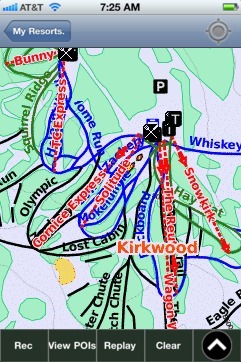
When you purchase our Ski App, you get all the great ski app features, along with Kirkwood gps ski map.
Want to know what others are saying about our app? Go here to see our reviews and coverage.
This app is available as part of USA/Canada Ski App package to suit your skiing needs.
Have more questions about the Ski App? Ask us.
| Kirkwood Ski Stats | | Location | Thimble Peak Covered Wagon Peak The Sisters Glove Rock | | Nearest city | Kirkwood, California | | Coordinates | 38°41′02″N 120°04′05″W / 38.684°N 120.068°W / 38.684; -120.068Coordinates: 38°41′02″N 120°04′05″W / 38.684°N 120.068°W / 38.684; -120.068 | | Vertical | 2,000 ft (610 m) | | Top elevation | 9,800 ft (3,000 m) | | Base elevation | 7,800 ft (2,400 m) | | Skiable area | 2,300 acres (930 ha) | | Runs | 65+ total 15% beginner 50% intermediate 35% advanced | | Longest run | 2.5 mi (4.0 km) | | Lift system | 15 lifts (2 high speed quads, 1 fixed-grip quad, 6 triple chairs, 1 double chair, 2 surface lifts, 2 magic carpets, 1 tubing lift) | | Lift capacity | passengers/hr | | Terrain parks | Burton Adventure Land Burton Progression Park K2 Stomping Grounds Border X Course | | Snowfall | ~500 in (1,300 cm) | | Night skiing | None | | Web site | www.kirkwood.com |
|
Kirkwood: Gps Ski Maps - iPhone Ski App |