|
The Loveland Ski Area is located near the town of Georgetown, Colorado. The area is one of the closest to the Denver metropolitan area and Front Range corridor, making it popular with locals.[1] It is...(From Wikipedia page of Loveland Ski Resort).
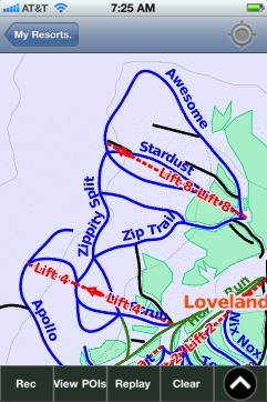
When you purchase our Ski App, you get all the great ski app features, along with Loveland gps ski map.
Want to know what others are saying about our app? Go here to see our reviews and coverage.
This app is available as part of USA/Canada Ski App package to suit your skiing needs.
Have more questions about the Ski App? Ask us.
| Loveland Ski Stats | | Location | Arapahoe National ForestClear Creek County,Colorado United States | | Nearest city | Georgetown | | Coordinates | 39°40′48″N 105°53′49″W / 39.68000°N 105.89694°W / 39.68000; -105.89694 (Loveland Ski Area) | | Vertical | 2,210 feet (670 m) Basin: 2,210 feet (670 m) Valley: 850 feet (260 m) | | Top elevation | 13,010 feet (3,970 m) Basin: 13,010 feet (3,970 m) Valley: 11,250 feet (3,430 m) | | Base elevation | 10,800 feet (3,300 m) Basin: 10,800 feet (3,300 m) Valley: 10,400 feet (3,200 m) | | Skiable area | 1,365 acres (5.52 km2) | | Runs | 77 total 13% beginner 41% intermediate 46% advanced/expert | | Longest run | 2 miles (3.2 km) | | Lift system | 11 total (3 quad chairlift, 2 triple chairs, 4 double chairs, 2 surface) | | Lift capacity | 14,293 / hour | | Terrain parks | 1 | | Snowfall | 420 in - (1066 cm) | | Snowmaking | 160 acres (0.65 km2) | | Night skiing | none | | Web site | Ski Loveland.com |
|
Loveland: Gps Ski Maps - iPhone Ski App |