|
Marmot Basin trail map is available as part of our USA/Canada Ski App. It is supported on iPhone / iPad, Android, Windows 8 Phone and Blackberry.
Marmot Basin is an alpine ski area located in Alberta's Jasper National Park. It has offered a broad variety of basin and glade skiing since it first served enthusiasts in 1961[citation needed] with a...(From Wikipedia page of Marmot Basin Ski Resort).
Want to know what others are saying about our app? Go here to see our reviews and coverage. This app is available as part of USA/Canada Ski App package to suit your skiing needs. Have more questions about the Ski App? Ask us.
|
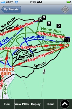 Marmot Basin: Gps Ski Maps - iPhone Ski App |
||||||||||||||||||||||||||||