Mount St Louis Moonstone(Ontario) Ski App


Mount St Louis Moonstone(Ontario) trail map is available as part of our USA/Canada Ski App. It is supported on iPhone / iPad, Android, Windows 8 Phone and Blackberry.  

Mount St. Louis Moonstone is a southern Ontario ski resort located north of Barrie. The resort is just over one hour driving time from Toronto and is located just off Highway 400, which makes it a pri...(From Wikipedia page of Mount St Louis Moonstone(Ontario) Ski Resort).
 When you purchase our Ski App,  you get all the great ski app features, along with Mount St Louis Moonstone(Ontario) gps ski map.


Want to know what others are saying about our app? Go here to see our reviews and coverage.

This app is available as part of  USA/Canada Ski App package to suit your skiing needs.

Have more questions about the Ski App? Ask us.


Mount St Louis Moonstone(Ontario) Ski Stats
LocationMoonstone, Ontario, Canada
Nearest cityBarrie
Coordinates44°37′36″N 79°40′07″W / 44.62667°N 79.66861°W / 44.62667; -79.66861 (Mount St. Louis Moonstone)
Vertical168 m (550 ft)
Top elevation382 m (1,252 ft)
Base elevation229 m (751 ft)
Skiable area75 ha (185 acres)
Runs40 35% – Easiest 50% – More Difficult 15% – Most Difficult
Longest run1,609 m (5,280 ft)
Lift system13 (3 detachable sixies, 1 detachable quad, 2 quads, 2 triples, 1 double, 3 magic carpets)
Lift capacity23,600 per hour
Snowfall3 m (120 in)
Snowmaking100%
Night skiingPlanned
Web siteMount St. Louis Moonstone


Mount St Louis Moonstone(Ontario) ski map - iPhone Ski App
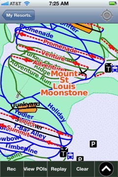
Mount St Louis Moonstone(Ontario): Gps Ski Maps - iPhone Ski App