Mt Bachelor Ski App


Mt Bachelor trail map is available as part of our USA/Canada Ski App. It is supported on iPhone / iPad, Android, Windows 8 Phone and Blackberry.  

Mount Bachelor ski area is a ski resort located in central Oregon, approximately 22 miles (35 km) west of Bend, at the end of Century Drive Highway. The ski runs are on the northern face of Mount Bac...(From Wikipedia page of Mt Bachelor Ski Resort).
 When you purchase our Ski App,  you get all the great ski app features, along with Mt Bachelor gps ski map.


Want to know what others are saying about our app? Go here to see our reviews and coverage.

This app is available as part of  USA/Canada Ski App package to suit your skiing needs.

Have more questions about the Ski App? Ask us.


Mt Bachelor Ski Stats
LocationMount BachelorDeschutes County,Oregon, U.S.
Nearest cityBend: 22 mi (35 km) east
Coordinates44°0′11″N 121°40′40″W / 44.00306°N 121.67778°W / 44.00306; -121.67778Coordinates: 44°0′11″N 121°40′40″W / 44.00306°N 121.67778°W / 44.00306; -121.67778
Vertical3,300 ft (1,006 m)lift-served
Top elevation9,065 ft (2,763 m)Summit Express
Base elevation5,700 ft (1,737 m)Northwest Express 6,350 ft (1,940 m)Pine Marten Express
Skiable area3,683 acres (14.9 km2)
Runs88 total - 15% novice - 25% intermediate - 35% advanced - 25% expert
Longest run1.5 mi (2.4 km)
Lift system12 - 7 express quads - 3 triple chairs - 1 magic carpet - 2 tubing tows
Terrain parks5
Snowfall370 inches (940 cm)
SnowmakingYes
Night skiingnone
Web siteMt Bachelor.com


Mt Bachelor ski map - iPhone Ski App
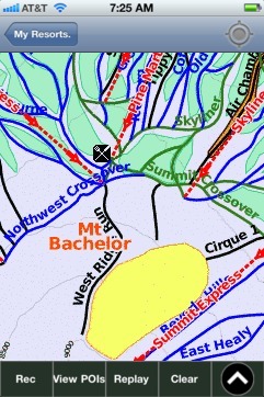
Mt Bachelor: Gps Ski Maps - iPhone Ski App