Mt Baker Ski App


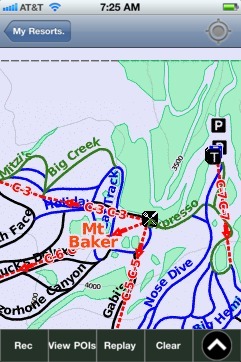
Mt Baker trail map is available as part of our USA/Canada Ski App. It is supported on iPhone / iPad, Android, Windows 8 Phone and Blackberry.  

Mt. Baker Ski Area is a ski resort located in Whatcom County, Washington, United States, at the end of State Route 542. The base elevation is at 3,500 feet (1,100 m), while the peak of the resort is ...(From Wikipedia page of Mt Baker Ski Resort).
 When you purchase our Ski App,  you get all the great ski app features, along with Mt Baker gps ski map.


Want to know what others are saying about our app? Go here to see our reviews and coverage.

This app is available as part of  USA/Canada Ski App package to suit your skiing needs.

Have more questions about the Ski App? Ask us.


Mt Baker Ski Stats
LocationGlacier, Washington, US
Nearest cityBellingham 52 miles (84 km) west - 1hr 15min drive
Coordinates48°51′30″N 121°40′38″W / 48.85833°N 121.67722°W / 48.85833; -121.67722 (Mt. Baker Ski Area)
Vertical1,589 ft (484 m)
Top elevation5,089 ft (1,551 m)
Base elevation3,500 ft (1,100 m)White Salmon Base Area 4,300 ft (1,300 m)Heather Meadows Base Area
Skiable area1,000 acres (4.0 km2)
Runs31 - 24% easiest - 45% more difficult - 31% most difficult
Lift system8 chairs, 2 rope tows
Snowfall641 in (1,630 cm)
Snowmakingno
Night skiingno
Web siteMt. Baker Ski Area


Mt Baker ski map - iPhone Ski App
Mt Baker: Gps Ski Maps - iPhone Ski App