Mt. Rose Ski App


Mt. Rose trail map is available as part of our USA/Canada Ski App. It is supported on iPhone / iPad, Android, Windows 8 Phone and Blackberry.  

Mount Rose Ski Tahoe is the closest ski resort to Reno, Nevada. It is located about 30 miles (50 km) south of Reno in the Carson Range. Mt. Rose is Tahoe's highest base elevation at about 8,260 ft (2...(From Wikipedia page of Mt. Rose Ski Resort).
 When you purchase our Ski App,  you get all the great ski app features, along with Mt. Rose gps ski map.


Want to know what others are saying about our app? Go here to see our reviews and coverage.

This app is available as part of  USA/Canada Ski App package to suit your skiing needs.

Have more questions about the Ski App? Ask us.


Mt. Rose Ski Stats
Coordinates39°19′45″N 119°53′09″W / 39.32917°N 119.88583°W / 39.32917; -119.88583 (Mount Rose)
Vertical1,800 feet (550 m)
Top elevation9,700 feet (3,000 m)
Base elevation7,900 feet (2,400 m)
Skiable area1,200 acres (4.9 km2)
Runs60+ - 20% beginner - 30% intermediate - 40% Advanced - 10% Expert
Longest run2.5 miles (4.0 km)
Lift system8 Lifts- 2 Six Pack, 2 Quad, 2 Triple, 2 Surface
Lift capacityskiers/hr
Terrain parksDoubleDown, Badlands, Black Jack Progression
Snowfall400 inches (10,000 mm) annually
Snowmaking28%
Night skiingNo
Web sitehttp://www.skirose.com/


Mt. Rose ski map - iPhone Ski App
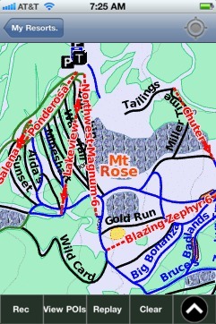
Mt. Rose: Gps Ski Maps - iPhone Ski App