Nakiska, AB Ski App


Nakiska, AB trail map is available as part of our USA/Canada Ski App. It is supported on iPhone / iPad, Android, Windows 8 Phone and Blackberry.  

Nakiska is a ski resort in western Canada, in the Kananaskis Country region of the province of Alberta. It is located 83 km (52 mi) from Calgary, west on Highway 1 (Trans-Canada Highway) and south o...(From Wikipedia page of Nakiska, AB Ski Resort).
 When you purchase our Ski App,  you get all the great ski app features, along with Nakiska, AB gps ski map.


Want to know what others are saying about our app? Go here to see our reviews and coverage.

This app is available as part of  USA/Canada Ski App package to suit your skiing needs.

Have more questions about the Ski App? Ask us.


Nakiska, AB Ski Stats
LocationMount Allan, Kananaskis, Alberta, Canada
Nearest cityCalgary: 83 km (52 mi)
Coordinates50°56′38″N 115°08′49″W / 50.944°N 115.147°W / 50.944; -115.147Coordinates: 50°56′38″N 115°08′49″W / 50.944°N 115.147°W / 50.944; -115.147
Vertical   779 m (2,556 ft)
Top elevation2,258 m (7,408 ft)[1]
Base elevation1,479 m (4,852 ft)
Skiable area3 km2 (1.2 sq mi)
Runs64 16% - Easiest 70% - More Difficult 10% - Most Difficult 4% - Expert
Longest run3.3 km (2.1 mi)
Lift system4 Chairlifts - 3 High Speed Quads - 1 Double - 1 Magic Carpet
Lift capacity8,830 / hr
Snowfall250 cm (100 in)
SnowmakingExtensive, 95%
Night skiingNo
Web siteSki Nakiska.com


Nakiska, AB ski map - iPhone Ski App
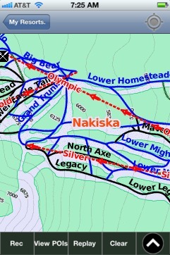
Nakiska, AB: Gps Ski Maps - iPhone Ski App