Northstar at Tahoe Ski App


Northstar at Tahoe trail map is available as part of our USA/Canada Ski App. It is supported on iPhone / iPad, Android, Windows 8 Phone and Blackberry.  

Northstar California (previously Northstar-at-Tahoe) is a mountain resort situated near the north shore of Lake Tahoe in Placer County, California, approximately 200 mi (320 km) from the San Francis...(From Wikipedia page of Northstar at Tahoe Ski Resort).
 When you purchase our Ski App,  you get all the great ski app features, along with Northstar at Tahoe gps ski map.


Want to know what others are saying about our app? Go here to see our reviews and coverage.

This app is available as part of  USA/Canada Ski App package to suit your skiing needs.

Have more questions about the Ski App? Ask us.


Northstar at Tahoe Ski Stats
LocationPlacer County, California
Nearest cityTruckee, California
Coordinates39°16′24″N 120°06′09″W / 39.2733°N 120.1025°W / 39.2733; -120.1025Coordinates: 39°16′24″N 120°06′09″W / 39.2733°N 120.1025°W / 39.2733; -120.1025
Vertical2,280 ft (690 m)
Top elevation8,610 ft (2,620 m)
Base elevation6,330 ft (1,930 m)
Skiable area2,904 acres (1,175 ha)
Runs93 total 13% beginner 60% intermediate 27% advanced
Longest run1.4 mi (2.3 km)
Lift system19 lifts
Lift capacity34,799 passengers/hr
Terrain parks7
Snowfall350 in (890 cm)
Snowmaking50%
Night skiingNo
Web sitehttp://northstarcalifornia.com


Northstar at Tahoe ski map - iPhone Ski App
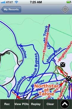
Northstar at Tahoe: Gps Ski Maps - iPhone Ski App