China Peak( Sierra Summit) Ski App


China Peak( Sierra Summit) trail map is available as part of our USA/Canada Ski App. It is supported on iPhone / iPad, Android, Windows 8 Phone and Blackberry.  

China Peak is a ski area in Central California. It opened in 1958, named after the mountain, Chinese Peak. In 1981 the resort was purchased by the Snow Summit company and the name was changed to Sierr...(From Wikipedia page of China Peak( Sierra Summit) Ski Resort).
 When you purchase our Ski App,  you get all the great ski app features, along with China Peak( Sierra Summit) gps ski map.


Want to know what others are saying about our app? Go here to see our reviews and coverage.

This app is available as part of  USA/Canada Ski App package to suit your skiing needs.

Have more questions about the Ski App? Ask us.


China Peak( Sierra Summit) Ski Stats
LocationChinese Peak
Nearest cityLakeshore, California
Coordinates37°13′47″N 119°09′30″W / 37.2297°N 119.1583°W / 37.2297; -119.1583Coordinates: 37°13′47″N 119°09′30″W / 37.2297°N 119.1583°W / 37.2297; -119.1583
Top elevation8,709 ft (2,655 m)
Base elevation7,030 ft (2,140 m)
Skiable area1,200 acres (490 ha)
Runs45
Longest run2.25 mi (3.62 km) (Academy)
Lift system11 lifts: 3 triples, 4 doubles, 2 handle tows, 1 t-bar, 1 moving carpet
Terrain parksFirebowl Canyonlands Burton Progression/Ullmann's Alley
Snowfall300 in (760 cm)
Night skiingNone
Web sitewww.SkiChinaPeak.com


China Peak( Sierra Summit) ski map - iPhone Ski App
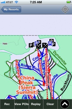
China Peak( Sierra Summit): Gps Ski Maps - iPhone Ski App