|
Snowbasin Resort is located 33 miles (53 km) northeast of Salt Lake City, in Weber County, Utah. Opened in 1939, as part of an effort by the city of Ogden, Utah to restore the Wheeler Creek watershed...(From Wikipedia page of Snowbasin Ski Resort).
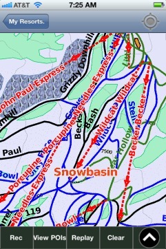
When you purchase our Ski App, you get all the great ski app features, along with Snowbasin gps ski map.
Want to know what others are saying about our app? Go here to see our reviews and coverage.
This app is available as part of USA/Canada Ski App package to suit your skiing needs.
Have more questions about the Ski App? Ask us.
| Snowbasin Ski Stats | | Location | Mount OgdenWeber County, Utah United States | | Nearest city | Ogden, Utah | | Coordinates | 41°12′43″N 111°51′07″W / 41.21194°N 111.85194°W / 41.21194; -111.85194Coordinates: 41°12′43″N 111°51′07″W / 41.21194°N 111.85194°W / 41.21194; -111.85194 | | Vertical | 2,950 ft (900 m) | | Top elevation | 9,350 ft (2,850 m) | | Base elevation | 6,391 ft (1,948 m) | | Skiable area | 3,000 acres (1,200 ha) | | Runs | 104 20% easiest 50% more difficult 30% most difficult | | Longest run | Elk Ridge 2.9 mi (4.7 km) | | Lift system | 11Chairs: 9 - 1 tram - 2 gondolas - 2 high speed quads - 4 fixed-gripSurface: 2 - 1 Magic carpet - 1 surface tow (tubing hill) | | Lift capacity | 14,650 skiers/hr | | Terrain parks | 3 1 superpipe | | Snowfall | 350 inches (890 cm) | | Snowmaking | 600 acres (240 ha) | | Night skiing | No | | Web site | Snowbasin Resort |
|
Snowbasin: Gps Ski Maps - iPhone Ski App |