|
5.3 Miles (8.5 km)(From Wikipedia page of Snowmass Ski Resort).
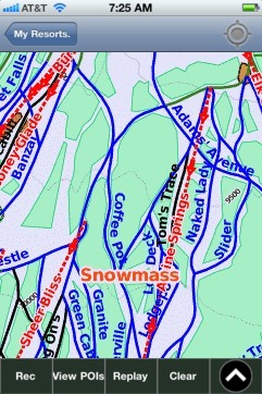
When you purchase our Ski App, you get all the great ski app features, along with Snowmass gps ski map.
Want to know what others are saying about our app? Go here to see our reviews and coverage.
This app is available as part of USA/Canada Ski App package to suit your skiing needs.
Have more questions about the Ski App? Ask us.
| Snowmass Ski Stats | | Coordinates | 39°11′44″N 106°57′05″W / 39.1956°N 106.9513°W / 39.1956; -106.9513Coordinates: 39°11′44″N 106°57′05″W / 39.1956°N 106.9513°W / 39.1956; -106.9513 | | Vertical | 4,406 ft (1,343 m) | | Top elevation | 12,510 ft (3,813 m) | | Base elevation | 8,104 ft (2,473 m) | | Skiable area | 3,128 acres (12.66 km²) | | Runs | 88 | | Longest run | 5.3 Miles (8.5 km) | | Types of Trails | easiest: 6%, more difficult: 50%, most difficult: 12%, expert: 32% | | Best Known For | Wide-open, groomed cruising and family-friendly activities. Snowmass has long been rated one of the best family ski areas in North America | | Location | Within the White River National Forest, adjacent to Snowmass Village and 9 miles (14 km) from downtown Aspen | | Terrain Parks and Half Pipes | 3 terrain parks (Snowmass Park and Superpipe, Little Makaha and Lowdown Park), 1 superpipe and 1 minipipe | | Restaurants | Base Camp Bar & Grille, Café Suzanne, Elk Camp, Gwyn"s High Alpine, Krabloonik, Lynn Britt Cabin (snowcat dinner rides), Burlingame Cabin (snowcat dinner rides), Two Creeks Mexican Café, Ullrhof, Up 4 Pizza, Sam's Smokehouse, Sneaky's Tavern. | | Company website | www.aspensnowmass.com |
|
Snowmass: Gps Ski Maps - iPhone Ski App |