Squaw Valley USA Ski App


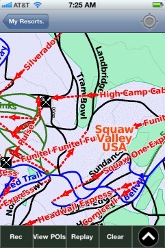
Squaw Valley USA trail map is available as part of our USA/Canada Ski App. It is supported on iPhone / iPad, Android, Windows 8 Phone and Blackberry.  

Squaw Valley Ski Resort in Olympic Valley, California, is one of the largest ski areas in the United States, and was the site of the 1960 Winter Olympics.[1] It is the second-largest ski area in Lake ...(From Wikipedia page of Squaw Valley USA Ski Resort).
 When you purchase our Ski App,  you get all the great ski app features, along with Squaw Valley USA gps ski map.


Want to know what others are saying about our app? Go here to see our reviews and coverage.

This app is available as part of  USA/Canada Ski App package to suit your skiing needs.

Have more questions about the Ski App? Ask us.


Squaw Valley USA Ski Stats
LocationSquaw PeakPlacer County, California
Nearest cityTruckee, California
Coordinates39°11′18″N 120°15′50″W / 39.1882°N 120.2639°W / 39.1882; -120.2639Coordinates: 39°11′18″N 120°15′50″W / 39.1882°N 120.2639°W / 39.1882; -120.2639
Vertical2,850 ft (870 m)
Top elevation9,050 ft (2,760 m)
Base elevation6,200 ft (1,900 m)
Skiable area4,000 acres (1,600 ha)
Runs177+ - 15% easiest - 35% more difficult - 50% most difficult
Longest runMountain Run3.2 mi (5.1 km)
Lift system33
Lift capacity58,000 passengers/hr
Terrain parks3
Snowfall450 in (1,100 cm)
Snowmakingyes
Night skiingyes
Web sitewww.squaw.com


Squaw Valley USA ski map - iPhone Ski App
Squaw Valley USA: Gps Ski Maps - iPhone Ski App