|
Stowe trail map is available as part of our USA/Canada Ski App. It is supported on iPhone / iPad, Android, Windows 8 Phone and Blackberry.
Stowe Mountain Resort is a ski resort in the northeastern United States, near the town of Stowe in northern Vermont, comprising two separate mountains: Mount Mansfield and Spruce Peak. The lift-served...(From Wikipedia page of Stowe Ski Resort).
Want to know what others are saying about our app? Go here to see our reviews and coverage. This app is available as part of USA/Canada Ski App package to suit your skiing needs. Have more questions about the Ski App? Ask us.
|
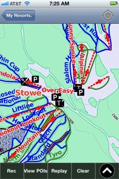 Stowe: Gps Ski Maps - iPhone Ski App |
||||||||||||||||||||||||||||||||||
Stowe users
| Ski Resort | Type | Info | Date |
|---|---|---|---|
| Stowe | Track | 4 runs, max 11.5 m/s, avg 2.05 m/s, 7 green, 10 blue, 2 black, Tracked on App | Tuesday, March 10th, 2015 |
| Stowe | Track | 5 runs, max 16.0 m/s, avg 2.83 m/s, 1 green, 18 blue, Tracked on App | Sunday, March 8th, 2015 |
| Stowe | Track | 5 runs, max 15.0 m/s, avg 4.34 m/s, 10 green, 13 blue, 1 black, Tracked on App | Sunday, March 8th, 2015 |