Sugar Bowl Ski App


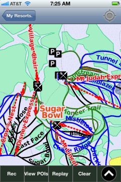
Sugar Bowl trail map is available as part of our USA/Canada Ski App. It is supported on iPhone / iPad, Android, Windows 8 Phone and Blackberry.  

Sugar Bowl is a ski and snowboard area in northern Placer County near Norden, California along the Donner Pass of the Sierra Nevada, approximately 46 mi (74 km) west of Reno, Nevada on Interstate 80...(From Wikipedia page of Sugar Bowl Ski Resort).
 When you purchase our Ski App,  you get all the great ski app features, along with Sugar Bowl gps ski map.


Want to know what others are saying about our app? Go here to see our reviews and coverage.

This app is available as part of  USA/Canada Ski App package to suit your skiing needs.

Have more questions about the Ski App? Ask us.


Sugar Bowl Ski Stats
LocationPlacer County, California in the Lake Tahoe region
Nearest cityNorden, California
Coordinates39°18′16″N 120°20′09″W / 39.30444°N 120.33583°W / 39.30444; -120.33583Coordinates: 39°18′16″N 120°20′09″W / 39.30444°N 120.33583°W / 39.30444; -120.33583
Top elevation8,383 ft (2,555 m)
Base elevation6,883 ft (2,098 m)
Skiable area1,500 acres (610 ha)
Runs94 total 17% beginner 45% intermediate 38% advanced
Longest run3 mi (4.8 km)
Lift system13 lifts (5 high speed quads, 3 quads, 2 double chairs, 1 gondola, 2 surface lifts
Lift capacity21,740 passengers/hr
Snowfall550 in (1,400 cm)
Web sitewww.sugarbowl.com


Sugar Bowl ski map - iPhone Ski App
Sugar Bowl: Gps Ski Maps - iPhone Ski App