Summit at Snoqualmie Ski App


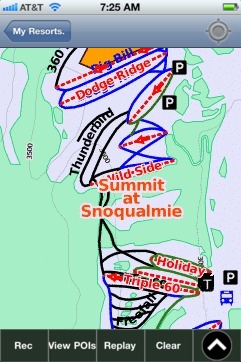
Summit at Snoqualmie trail map is available as part of our USA/Canada Ski App. It is supported on iPhone / iPad, Android, Windows 8 Phone and Blackberry.  

The Summit at Snoqualmie, located on Snoqualmie Pass, Washington, is a winter resort providing alpine skiing and snowboarding, Nordic skiing, and winter tubing owned by CNL Investment Properties, Inc....(From Wikipedia page of Summit at Snoqualmie Ski Resort).
 When you purchase our Ski App,  you get all the great ski app features, along with Summit at Snoqualmie gps ski map.


Want to know what others are saying about our app? Go here to see our reviews and coverage.

This app is available as part of  USA/Canada Ski App package to suit your skiing needs.

Have more questions about the Ski App? Ask us.


Summit at Snoqualmie Ski Stats
LocationSnoqualmie Pass, Washington, United States
Nearest cityNorth Bend (18 miles west)
Coordinates47°24′36″N 121°24′21″W / 47.41000°N 121.40583°W / 47.41000; -121.40583 (The Summit at Snoqualmie)
Vertical2,280 ftAlpental – 2,280 ftSummit Central – 1,025 ftSummit West – 765 ftSummit East – 1,100 ft
Top elevation5420 ft (Alpental)
Base elevation2610 ft (Summit East)
Skiable area1,914 acres (7.75 km2) (combined)
Runs62 (combined) - 14% easiest - 45% more difficult - 41% most difficult
Longest run1.2 mi International
Lift system18 chairs, 6 surface liftsAlpental: 4 chairs, 1 surface liftSummit Central: 7 chairs, 3 surface liftsSummit West: 5 chairs, 2 surface liftsSummit East: 2 chairs
Snowfall435 in
Web sitesummitatsnoqualmie.com - official site


Summit at Snoqualmie ski map - iPhone Ski App
Summit at Snoqualmie: Gps Ski Maps - iPhone Ski App