Sunrise Park Ski App


Sunrise Park trail map is available as part of our USA/Canada Ski App. It is supported on iPhone / iPad, Android, Windows 8 Phone and Blackberry.  

Sunrise Park Resort is a ski resort located near Greer, Arizona, close to the border with New Mexico. The resort consists of three mountains named Sunrise Peak, Cyclone Peak, and Apache Peak. Situated...(From Wikipedia page of Sunrise Park Ski Resort).
 When you purchase our Ski App,  you get all the great ski app features, along with Sunrise Park gps ski map.


Want to know what others are saying about our app? Go here to see our reviews and coverage.

This app is available as part of  USA/Canada Ski App package to suit your skiing needs.

Have more questions about the Ski App? Ask us.


Sunrise Park Ski Stats
LocationApache County, Arizona, USA
Nearest cityGreer, Arizona
Coordinates33°58′24″N 109°33′53″W / 33.97333°N 109.56472°W / 33.97333; -109.56472Coordinates: 33°58′24″N 109°33′53″W / 33.97333°N 109.56472°W / 33.97333; -109.56472
Vertical1,800 ft (550 m)
Top elevation11,100 feet (3,400 m)
Base elevation9,200 feet (2,800 m)
Skiable area800 acres (3.2 km2)
Runs65 total 40% beginner 40% intermediate 20% advanced/expert
Longest run1.2 miles (1.93 km) "Sidewinder"
Lift system10 total 3 Quad chairs, 4 triple chairs, 1 double chairs, 2 Surface)
Lift capacity16,000 / hr
Terrain parks1
Snowfall250 in/year ( 6.35 m/year)
SnowmakingYes
Night skiingYes (4:30 p.m. - 9:00 p.m. on limited days)
Web sitehttp://www.sunriseskiparkaz.com


Sunrise Park ski map - iPhone Ski App
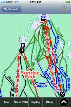
Sunrise Park: Gps Ski Maps - iPhone Ski App