Whitetail, PA Ski App


Whitetail, PA trail map is available as part of our USA/Canada Ski App. It is supported on iPhone / iPad, Android, Windows 8 Phone and Blackberry.  

Whitetail Mountain Resort is a four season resort located on Two Top Mountain in the Tuscarora Mountains of Pennsylvania. The resort opened for skiing in 1991, and was acquired a few years later by Sn...(From Wikipedia page of Whitetail, PA Ski Resort).
 When you purchase our Ski App,  you get all the great ski app features, along with Whitetail, PA gps ski map.


Want to know what others are saying about our app? Go here to see our reviews and coverage.

This app is available as part of  USA/Canada Ski App package to suit your skiing needs.

Have more questions about the Ski App? Ask us.


Whitetail, PA Ski Stats
LocationMontgomery Township, Franklin County, Pennsylvania, USA
Nearest cityClear Spring, Maryland
Coordinates39°44′30″N 77°55′58″W / 39.74167°N 77.93278°W / 39.74167; -77.93278 (Whitetail Ski Resort)
Vertical935 feet (285 m)
Top elevation1,800 feet (550 m)
Base elevation865 feet (264 m)
Skiable area109 acres (0.44 km2)
Runs21 total 30% beginner 45% intermediate 25% advanced
Longest run"Limelight" ~ 4,900 feet (1494 m)
Lift system9 total (1 high-speed quad chairs, 3 quad chair, 2 double chairs, 2 surface)
Terrain parks2
Snowfall40 in/year (1 m/year)
Snowmaking100%
Night skiing95%
Web sitehttp://www.skiwhitetail.com


Whitetail, PA ski map - iPhone Ski App
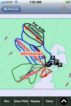
Whitetail, PA: Gps Ski Maps - iPhone Ski App